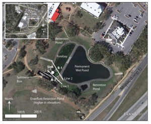
Understanding groundwater flow patterns is critical in determining where potential contaminants are likely to be deposited from storm water runoff or potential industrial spill events. In January 2012, a large sinkhole formed below the storm water retention pond at Arbor Trails, a commercial development within the City of Austin. Nearly 7 million gallons of untreated water was absorbed into the local groundwater aquifer systems. This study used dye tracing to answer the question of what pathways the water from this discharge event followed and what aquifer would be most likely be impacted by contaminants entering the groundwater system from that location in the future.
Spatial methods that were used to address the question of groundwater flow from the ATS site included an overview map of the research area that included the Edwards Aquifer Recharge Zones with a scale feature; county lines, rivers and spring sites; and the location labeled within a state map of Texas. Images in google earth were labeled with key features of the storm water retention pond and sinkhole at the Arbor Trails site location. The dye tracing results were displayed on a scaled and contoured map that showed the test site along with 10 previous tests with inferred flow paths ending near the Barton Springs area.
The Barton Springs section of the Edwards Aquifer was the expected location for dyes to be deposited and results confirmed that it takes approximately 4 days from the Arbor Trails location to reach this location. Future data that confirms groundwater flow patterns in the region is needed. This article and additional information can be found at https://www.researchgate.net/publication/265593023_Dye_Tracing_Results_from_the_Arbor_Trails_Sinkhole_Barton_Springs_Segment_of_the_Edwards_Aquifer_Austin_Texas


