
By: Ryan Carl Dolezal
ABSTRACT
The Nubian Sandstone Aquifer is the largest known fossil aquifer ever discovered. The word “fossil’ indicates the aquifer’s water, by the use of radiocarbons, has been stored for hundreds of thousands of years. The total and useful volumes vary greatly but current studies are underway to find these factors so that users may understand and use the resource with the best management available. The aquifer lies beneath four northeast African countries (Egypt, Libya, Sudan, and Chad) and due to the climate of this Sahara Desert region, this source has become a great interest to many in these countries. There have been attempts to manage the resource equally but nothing has withstood an agreement for a long period of time. This study will focus on the geologic and management relationships of the aquifer with the four riparian countries and will be supplemented with a doctrine of management that may suit the equitable and long term needs of all users. Analysis of the criteria of this suggested doctrine, as well as the other criteria of interest, will be provided with description, examples, and figures so the reader might fully grasp the array of factors to consider when attempting to appropriately manage transboundary water resources.
The Nubian Sandstone Aquifer Dispute
I. Introduction
Developed countries have been resourceful to the point where every person can expect water to run once the faucet is turned on. It is a beautiful commodity that Americans take for granted every day. Water is essential to life in every shape and form and the supply/resources in many other places in the world are not as readily available. The increase in population, advancement in technology and migration to densely populated areas are a few of the factors many developing countries are struggling to manage with water resources. The main issue at hand: how much readily available water is there and how long will it last? In the northeast sector of the African continent, the main issue could not be more apparent. This study will focus on the Nubian Sandstone Aquifer System (NSAS), the largest known fossil aquifer currently available. The NSAS underlies the countries of Libya, Sudan, Chad, and Egypt. Currently, there is not a collaborative agreement to govern the uses of the aquifer which makes this underground pool of water in the middle of the desert, all for the taking.
This report will first introduce the aquifer’s connectivity and location as it relates to the four countries. A further study of the four countries’ current needs and uses of water resources will be identified and followed with the failed attempts to accept an organized and responsible agreement between the nations. Research will conclude with an analysis of possible groundwater policies that would be case specific to the NSAS and a suggested doctrine that attempts to meet the most appropriate use of the reservoir. Each of these aspects illustrates the trials multiple governances continue to face when appropriating transboundary water resources.
II. Hydrology and Geography
The NSAS is the largest fossil groundwater reservoir in the world, currently recorded. A groundwater reservoir is termed “fossil”, or non-renewable, due to the slow rate of recharge; this term infers there is a limit to a volume readily available and a volume that can be extracted and made useful to the public through technology applications. Most of NSAS’ water has been dated by radiocarbon technology from 100,000 to 1,000,000 years old. Once the two limits are extracted the reservoir’s value will cease to exist and the societies dependent on this resource will need to look for another reli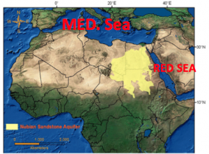 able source. The northernmost boundary of the NSAS is the Mediterranean Sea, the east is the Suez Canal and Red Sea, the west and south are more vague and have been determined by models created by Thorweihe and Hrinl (1996, cited by Margane, personal communication 2007) (figure 1).

The NSAS’ source is the Mediterranean Sea and it flows from north to south. The little recharge that does exist is from seepage from the Nile (Gossel / Ebraheem / Wycisk 2004). The system is split into two parts, Nubian Sandstone Aquifer (NSA) and Post-Nubian Sandstone Aquifer (PNA). The NSA is more readily available and, in northern regions of the NSAS and confined beneath is the PNA (Bakhbakhi 2006; Salem/ Pallas, 2002). The depth of the NSAS reaches a maximum of 4,500 meters. The most difficult, and most important, information to provide is a reasonable estimation of the volume of water in the NSAS. Research ranges anywhere from 15,000 cubic kilometers (Ambroggi, 1966) and 135,000 cubic kilometers, (Gossel / Ebraheem / Wyick 2004) with as much as 457,550 km^3 (CEDARE 2002; Bakhbkhi 2006). The accessible volume ranges from 0.15 km^3 to 8.8 km^3. For this study, data of percentages and totals will be referenced from the CEDARE study.
The NSAS underlies Libya, Chad, Sudan, and Egypt. Three pieces of data will begin to depict the criterion to formulate an apportionment system, or fragmenting use of the system: population, percentage of land overlying the aquifer, and percentage of total volume under the land of the aquifer. Countries are described and listed in order from largest percentage of land over the aquifer. Egypt, with 82 million people, has 38% of the land covering the aquifer with 41.5% of the NSAS’ volume underneath its land. Libya, population of 6.2 million, has 34% land coverage with 36.6% of the NSAS’ volume. Sudan, population of 38 million, has 17% land coverage with 9% of the NSAS’ volume. Chad, with a population of 12. 8 million, has 11% land coverage with 12. 8% of the NSAS’ volume (CEDARE 2002 cited in: Bakhbakhi 2006, 75; Abu-Zeid s.a., 2). (figure 2).
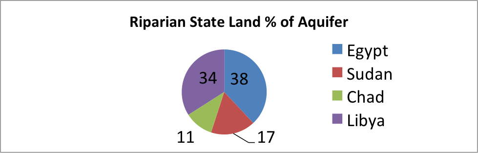
Figure 2: The pie chart depicts the different percentages for riparian state’s land over the aquifer. (CEDARE, 2002)
III. Development and Use
The age of this aquifer is characterized by finding the how long the water molecules have been in this aquifer. By the use of radiocarbon dating, the molecules can be associated with the soils and other matter within the aquifer; this information can quantify recharge rate and quality of the different layers of the aquifer. Research has found, through these measures described, the NSAS water ages between 100,000 to 1,000,000 years and large scale use from this source is only in its infancy (Himida 1969 cited in Zektser / Everett 2004, 221).
Apart from population, land percentages and volume percentages, the countries’ technology and dependency are also important factors to evaluate. The NSAS is not the only source of freshwater the four countries have to draw from and population density varies over the aquifer. All of these countries have climates that include the heat and dryness from the Sahara Desert. When there is not a reliable freshwater source, communities do not thrive and choose to move to more suitable areas. This has water management and philosophers asking the question: If people do not live above or remotely near, estimate 10 miles, to the source, is the country still entitled to the NSAS’ resource? Ten miles may not seem far for a vehicle to travel. Ten miles of infrastructure, however, to transfer water that begins hundreds of feet underneath the surface can be extremely costly to quench the thirst of small communities in the desert. If a government decides to invest in pump and transfer infrastructure, the factors to consider are the radius of populations from the source and appropriate size of these populations to consider investing in; is a hundred miles of pipe necessary for a hundred people or a thousand people… or more?
A simple policy for allocation is to use the percentage of land above the aquifer; Egypt would be allocated 41.5% of the total volume of the NSAS. This type of policy would not be agreed upon the four riparian countries. Egypt uses the Nile River for 93% of their water demand, leaving 7% is from groundwater reservoirs. Of the 7%, 1.2% is drawn from the NSAS and most of the extraction is used for agriculture irrigation where there is a large loss in evaporation (FAO 2005b). This example is given to further explain there should be additional factors like dependency and best management practices/technology are necessary criterion to consider.
Libya’s dependency on the NSAS far surpasses the other riparian states with 95% of their water demand from non-renewable groundwater. Also, 98.72% of Libya’s irrigation demand is met from groundwater (FAO, 2005c). More uses include domestic needs and oil production. From the 11% of land percentage over the aquifer, it is simple to guess the majority of the population lives over this area. However, 80% of the people live on the coastal areas, about 2485 miles from the land over the NSAS (figure 3) (FAO2005c). This is made possible with Libya’s massive water pipeline known as “The Great Man-made River” (GMMR). With over four thousand kilometers of pipeline and 25$US billion invested into the five phase GMMR project, the distribution of the NSAS reaches Libya’s coastline in various destinations.
The uses of the aquifer were originally set out to supply for agriculture and development. Plans for a sustainable source of food, water, and advancement of economy has caused the region to be more densely populated in this region and thus, more dependent on the GMMR. The annual supply from the GMMR (6.5 billion cubic meters) may only meet half of the total demand in 2025 (IWMI, 2004). The project is a landmark seen from space and a proud staple of the Libyan nation, but the cost of infrastructure and efficiency of agricultural uses have made critics question the investment and alternative sources of water. These inefficiencies in agricultural uses are due to centre-pivot systems. This system is great for distribution to a selected area but with the arid air and consistent high temperatures of the Saharan desert, it is very inefficient; 20% of the use is evaporated before it can be percolated into the soil (IWMI, 2004).
Figure 3

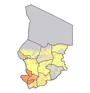
The people of Chad have been dependent on resources other than the NSAS. The desert climate is over the northern half of the country but the southern half has more vegetation and consistent rainfall (figure 4). The NSAS is located in the region of Chad where the least amount of people choose to live (figure 5). Another factor is technology feasibility. The nation’s GDP, 13.947US$ billion, ranks 24th out of the 53 nations of the African continent (statistics-times.com, 2016). To implement an infrastructure that matches the GMMR and provides water thousands of miles away would be an heavy fraction of the country’s funds and would take multiple generations to pay for and complete, as does the GMMR.
Figure 4
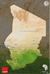
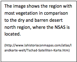
Figure 5

Sudan has more to gain and lose, when discussing the feasibility of using the NSAS. Sudan has a precipitation of 25mm annually and most of their dependency is from the Nile Nubian Aquifer (FAO, 2005d). Their GDP, 77.816US$ billion, ranks 7th in Africa and has 38 million people, second most of the four riparian states (statistics-times.com, 2016). Its population is spread out east to west but more concentrated in the central and southern half of the country. Sudan’s dependency currently relies on the Nile Nubian Aquifer but sources report various areas could face difficulties due to over extraction and river leakage in as little as 26 years (Algafar, Abdou, Abdelsalem, 2011). Another source of groundwater would alleviate the extreme current use of the Nile Nubian Aquifer; Sudan’s options look to be running thin and meeting with current users of the NSAS would be a great benefit to theirs if they were included as a user in any treaty.
IV. Government policy and research
There are several types of implementations of policy when it comes to governing and providing professional management to groundwater resources. These factors play a role as well because these types of institutions, when compared to one another, often have many disagreements between political and scientific points of view. The following lists the types of policy applied to groundwater:
- Correlative: all overlying landowners above the aquifer have equal and correlative right to use the groundwater with beneficial use. In times of shortage, appropriations can be made depending on basis of beneficial use.
- Rule of Capture: also referred to “law of the biggest pump”. A land owner has the right to extract as much water from an aquifer for use, sell, or waste
- Reasonable on-site use: Landowner may extract and use water in any form that is not considered a waste AND cannot use the source or sell the source outside the boundaries of the owners land.
- Reasonable off-site use: Landowner may extract, use and sell water on and/or off site so long as the use it not considered a waste.
- Common Law: “first in time first in right” appropriation through government entity according to the date of application.
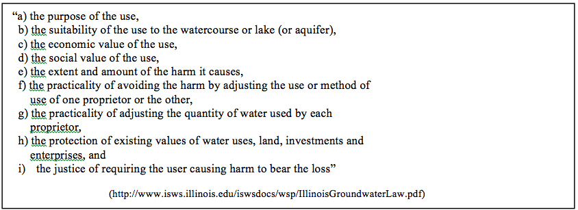
- Restatement of Torts: Landowner’s right is only limited when unreasonable use interferes with a neighbor’s use. These rights are similar to the correlative rights policy but differ by comparing unreasonable uses. Three bases for unreasonable uses includes well interference, monopolization and diversion from surface water. Tests of reasonable uses are referred to in cases of well interference in which reasonable amount of withdrawals effect neighbor’s uses. Tests include the following parameters:
- “a). the purpose of the use,
- b). the suitability of the use to the watercourse or lake (or aquifer),
- c). the economic value of the use,
- d). the social value of the use,
- e). the extent and amount of harm it causes,
- f). the practicality of avoiding the harm by adjusting the use or method of use of one proprietor or the other,
- g). the practicality of adjusting the quantity of water used by each proprietor,
- h). the protection of existing values of water uses, land, investments and enterprises, and
- i). the justice of requiring the user causing harm to bear the loss” (Clark, 1985).
Research for users of the aquifer and between users of the aquifer is essential to adequate management of the aquifer. Volumes of extraction, storage, uses and chemical composition of the water extracted are a few of the factors that managers can gather to manage the system as a collective unit of inflows and outflows and can tend to areas that request more assistance.
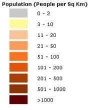
IV.a. Egypt Management
The management for Egypt’s groundwater is the federal government owns water. Its main agency for water management and development projects is the Ministry of water Resources and Irrigation (MWRI) and is part of the multi-national group Euro-Mediterranean Information System on know-how in the Water sector (EMWIS). The institutions and arrangement of responsibilities is very accessible and transparent to the public (figure 6). The Ministry is made up of five authorities of which are to provide to one purpose or skill. Under these authorities are offices that provide organization of accounts, training, and planning for their counterparts. The irrigation sector is the responsible party for groundwater resources and has a department focused in the southern and western part of the country. The National Water Research Center is made of 12 institutes, one specifically is the Research Institute of Groundwater (RIGW). RIGW is the main source in groundwater management for Egypt (Abu-Zeid, s.a.). The law for groundwater is somewhat complex for the NSAS. Most users in the country as subject to acquiring a water permit when using a well; this would involve irrigation schemes from the NSAS. However, the law also allows allocation for the ownership of groundwater for “traditional” agricultural uses in oases and in wadis, which would also involve the NSAS (Abu-Zeid, s.a.).
Figure 6
IV.b. Sudan management
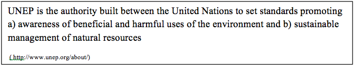
Sudan’s management of groundwater and surface water resources is led by the Ministry of Irrigation and Water Resources (MIWR) but there is not a clear policy framework for groundwater resources (Abdo and Salih, 2012). The groundwater specific issues are gathered and attended to by the Directorate of Groundwater and Wadis. Responsibilities of the MIWR in Sudan include planning and management in allocation of uses, international cooperation, research and execution of various irrigation schemes, control of water extraction, provisions for hydropower and protection of aquatic environments (FAO s.a.256). This language has not been upheld to its fullest content however because integration of records have been underachieved. However, Sudan’s government has received assistance from the United Nation’s Environment Program to help achieve their water management goals (UNEP: figure 7). In the case of Sudan, UNEP has assisted through efforts in monitoring and mitigation in over 200 wells declared vulnerable to groundwater depletion. Other assistance has involved research and mass studies between the Sudanese and South African approaches to integrated water resource management, funding to improve efficiency in water supplies in major cities, development in rainwater harvesting projects, and drought contingency planning in many areas (Tearfund, 2007).
Figure 7
IV.c. Libya’s Management
Libya’s organization of water management includes six institutions that integrate responsibilities for water projects and policy. These institutions are 1) General Water Authority, 2) National Company for Water and Waste Water, 3) Great manmade River Authority, 4) National Company for Desalination under the Secretariat of Electricity, Water and Gas, 5) Local Companies for Water and Waste Water, and 6) Great Manmade River Water Utilization for Agriculture. Libya’s efforts at water management include restatement of torts for groundwater: “An old water law exists whose main principal’s say that water is a commodity shared by all people…” All surface and groundwater resources are allowed to be had at infinite volumes and for any use so long as “it shall not cause damage to water or its source or to the land and installations constructed theron or adjacent thero” (FAO, 2009) This law was amended in 1982 to declare a boundary specified for the protection against overexploitation and pollution of aquifers, yet the enforcement of these goals is questioned organization held responsible, General Water Authority (FAO, 2009).
IV.d. Chad’s management
Chad’s groundwater management is guided by Chad’s Ministry of Environment and Water. The law governing groundwater resources involves rule of capture. UNEP describes the framework and efforts of Chad’s groundwater management as “limited” and “instruments and authority to ensure compliance and enforce agreements are lacking…” (UNEP, 2004). Sources are limited as well for public access. Chad’s management mostly attends to surface water resources, specifically Lake Chad. The geographical placement of Lake Chad provides for over 20 million people over several states, even though Chad alone has less than 14 million. A story from a young woman translates the massive loss of resources in a short amount of time. She expresses the lake was full of water and vegetation on the banks of Lake Chad. Now almost 95% of the lake has dried up since 1960 (figure 8) (Bloemen, 2009). There have been increased efforts for research and conservation but due to inaccuracies of available storage in prior years, Lake Chad could be a useless resource in 20 years. (Bloemen, 2009). This factors several million people that will need to move elsewhere to find a reliable water source and the NSAS would certainly be an option that the people of Chad would be fortunate to have.
Figure 8: A young woman’s personal experience of seeing Lake Chad’s water levels decline over her lifetime. 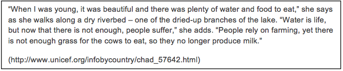
Regional Strategy for the Utilization of the Nubian Sandstone Aquifer System
There has been an integrated research effort between each of the four riparian countries since March of 2000. The Regional Strategy for the Utilization of the Nubian Sandstone Aquifer System is a two part agreement in which the riparian states monitor and collect groundwater use as well as openly share between the other states via the Nubian Aquifer Regional Information System (NARIS). The data includes water levels and drawdowns, quality, extraction volumes, and extraction frequency of the NSAS. Currently, there are over 2000 wells being monitored by the four regions (CEDARE). Organizations like these help determine appropriate strategies to provide in times of drought. In this area, every year is on the brink of a drought year. Models of areas with higher production or greater drawdowns like the several in this report can improve probabilities of providing necessary amounts of water to the demands that needs it most.
V. Efforts to reach agreement
Before exploring the steps taken in the attempt and fail of a transboundary aquifer treaty of the NSAS, there are a few events including threats and invasions of water supplies that can further describe the importance of creating a transboundary treaty. In September 2013, a local tribe (possibly affiliated with Islamic State (IS) in Iraq and Syria) cut off water to Tripoli, capital of Libya, in hope to release a kidnapped victim. Tripoli relied on bottled for ten days (Podrasky, 2013). In spring 2012, Egypt took action against Ethiopia’s Grand Renaissance Dam plan on the Nile River which would provide East Africa with electricity. Even with report listing the plan would not decrease the amount of water flowing into Egypt, Egyptian military threatened to invade such plans (Podrasky, 2013). If there is not a framework and authority to provide for the safety of this resource, by the look of these stories a “water war” may occur.
Efforts to reach agreement began in 2000 when the Regional Strategy for the Utilization of the Nubian Sandstone Aquifer System (IAEA, 2013). Officials from the four governments met again in 2013 and initialed an agreement for joint management of the aquifer. Along with the monitor and data collection, it made a framework for institutions to address regional and national level concerns for uses of the aquifer. Concerns included potential growth, increased agricultural development, industrial and urban development activities. Organizations that also helped in the formulation of this agreement included the International Atomic Energy Agency (IAEA) and United Nations’ Global Environment Fund (UNDP-GEF) (IAEA, 2013). The occasion was referred to as a “milestone in joint transboundary water resource management”. The parties adjourned and set a date to advance the modeling and renew the treaty. In 2015, all parties except Libya’s made the meeting. Due to Libya officials’ absence, the treaty never advanced further.
VI. Proposal
Formation of this proposal will be introduced by each countries factor into different concerns that may arise in the proposal process. Following the introduction will be a formal doctrine of which accounts for these concerns and simply organizes policy, institutions and responsibilities for the riparian states. Nation’s government officials, citizens, and uses of the NSAS will be referred to as the nation’s name alone for simplicity.
It is important to include and involve all riparian states in the future formulation of policy and institutions of the NSAS in research and management (short term and long term). The state which will have the most difficulty in providing a claim in the NSAS is Chad. Chad has the least amount of land over the aquifer, a low amount of people (if any) reliant of the aquifer, and very low technological and economic feasibility to invest in a source linking project. Chad is currently one of the poorest countries in a collectively developing continent Africa, according to GDP. Though their situation is binding at the moment, Chad’s people, especially by Lake Chad, may need a new reliable source in the coming generation. Sudan has a similar situation to Chad but bears the burden of providing for more people; yet Sudan has more feasibility to make investments to link water resources. Egypt and Libya have the most to invest in projects concerning the NSAS. Egypt chooses not to use much of the NSAS while Libya plans to have some of the largest daily extraction volumes from groundwater ever recorded. An integrated approach for water management of the NSAS will encourage sustainability and equitable right to use the aquifer between all nations. It will also provide for a greater security from threats, previously suggested, as opposed to four countries acting alone.
There is not a current framework for the NSAS but from analyzing the current uses, the framework being practiced is rule of capture. This rule will not yield long term production from the aquifer from all of its riparian states. Libya could extract all of the available resources before Sudan and Chad have a chance to finish a project and leave many of millions of people without a reliable source of water. It is important to reestablish to notion: equitable right to use the water for long term. Correlative Rights, where land over the aquifer is the weighted factor in allocation, may be an appropriate solution to make the formulation simple. Every country would have the equitable right to use the aquifer. However, Libya’s beneficial use would share the same problems discussed in the rule of capture rule.
Prior Appropriation may not be the best management practice in this case; the policy may not be suitable because Sudan and Chad would not be able to apply for appropriation for a considerable amount of time (unless they apply for a permit for which they will not use for many years). Appropriation could work if Libya would allow a considerable decline in their current extraction practices. This act from Libya is not realistic because the investment, and debt, of the five phases of the GMMR that Libya has accumulated and will continue to accumulate until completion. If Libya’s current extractions meet the current demand, Libya could invest in better management practices for irrigation to decline evaporation loss. If this were agreed upon, the appropriations would have to be an annual basis and never to exceed a certain amount; to be concise: if Libya is currently extracting a million cubic meters per day to meet their demand, their appropriation would be for that amount. Appropriations would have to be given to riparian states by a management committee unbiased between the states and secure the sustainable and equitable use of the aquifer instead of the economic benefits of one.
Reasonable on-site use would not be appropriate in this case because of the need to transport to areas more densely populated like Libya’s coastline. Reasonable off-site use could be considered but due to the climate of the region, the problem would be similar to the rule of capture because almost all withdrawals would be to provide for municipal and irrigation uses. A court could deem a use unreasonable if they had a high evaporation loss. The Restatement of torts may provide the most necessary formulation for the sustainable and equitable use of the aquifer. The concern with this use is each withdrawal is specific and a court would bear the burden to make many decisions based on the factors listed (figure 9).
Figure 9: lists the factors for testing reasonable use during well-interference
VII. Formal Doctrine:
The Nubian Sandstone Aquifer System underlies four riparian states: Chad, Egypt, Libya and Sudan. The four countries all share the aquifer in the sense of having a percentage of the aquifer below their lands territories. This doctrine values each riparian state along with the sustainable and equitable right to use the aquifer.
The Regional Strategy for the Utilization of the Nubian Sandstone Aquifer System shall continue its efforts to provide data and analysis of uses and quality of the aquifer. All riparian states are responsible for providing information on a six month basis.
This treaty will use the Restatement of Torts groundwater policy to respond to the future uses of the NSAS. The formulation of a water appropriation committee shall be formed to respond the site specific cases of reasonable uses that will meet a certain limit of volume on extraction. This committee shall include three representatives from each country, one representing water management, one representing agricultural and irrigation uses, and a third representative that is concern specific for the country it represents. The concern specific to the country is assigned by the country and not by another entity. All representatives may have a team assigned as subcommittees but the three representatives from each state will be the only representatives to appropriate water uses. Meetings of data sharing will be every six months and meetings to make provisions, adjustments, and appropriations will be annually.
Volumes to be extracted less than the limit shall be given immediate access once the committee receives the appropriation application but not before then. This information is important to receive so the committee can adjust the total volumes extracted from the aquifers. This limit of volume from extractions of the NSAS will be assigned with a 7/12 vote and will be according to the data shared and models used to forecast the effects of the loss to the water table. Exceeding this limit will require an application to the appropriation committee covering volume rate to be extracted (i.e. million cubic meters per day), uses of the volumes and other additional factors deemed necessary by the committee. Failure to provide an appropriate amount of information, according to the committee, will not be considered in the appropriation process.
IMPORTANT NOTE: EXTRACTIONS/DEVELOPMENTS MADE PRIOR TO THE DATE OF THIS SIGNED AGREEMENT OF ALL NATIONS ARE REQUIRED TO REPORT AN APPLICATION FOR DATA SHARING/PLANNING PURPOSES.
EXTRACTIONS/DEVELOPMENTS MADE PRIOR TO THE DATE WILL BE ALLOWED WITHOUT NOTICE OF THE EXCEEDANCE LIMIT RULE. THIS INCLUDES LIBYA’S GREAT MANMADE RIVER PROJECT THROUGH PHASE 3.
Annual provisions, adjustments, and appropriations shall be accepted on a 7/12 vote. The committee will provide judgement of appropriations according to these factors ranked from most necessary to less important (by number with (1) ranking most necessary factor):
- the purpose of the use,
- the social value of the use,
- the protection of existing values of water uses, land, investments and enterprises
- the economic value of the use,
- the extent and amount of the harm it causes,
- the justice of requiring the user causing harm to bear the loss
- use of one proprietor over another,
- the practicality of adjusting the quantity of water used by each proprietor
It is this doctrine’s mission to provide responsible policy and institution for the sustainability and equitable right to use the aquifer for current and future generations. Consideration and collaborative efforts in advancements in best management practices for all uses of the aquifer will be organized from each riparian state so that the use of the aquifer can be efficiently maximized.
EACH REPRESENTIVE TO THE WATER APPROPRIATION COMMITTEE PLEASE SIGN BELOW IN AGREEMENT TO THE MISSION AND RESPONSIBILITIES ASSIGNED FROM THIS TREATY CONCERNING THE NUBAIAN SANDSTONE AQUIFER SYSTEM:
Chad:__________________ _________________ ______________________ Date:_______
Egypt:__________________ _________________ ______________________ Date:_______
Libya:__________________ _________________ ______________________ Date:_______
Sudan:__________________ _________________ ______________________ Date:______
Bibliography
Abdo, G. and Salih, A., 2012. Challenges facing groundwater management in Sudan. Global Advanced Research Journal of Physical and Applied Sciences (GARJPAS) Vol (1). Department of Engineering, University of Khartoum. Khartoum, Sudan.
Abu-Zeid, K. M. (s. a.): Regional Management of the Nubian Sandstone Aquifer. Potential Arab Region & Latin America Cooperation on Large Aquifers; online: http://www2.mre.gov.br/aspa/semiarido/data/ Palestr%20Khaled% 20Abu-Zeid.doc
Algafar, M., Abdou, G., and Abdelsalam, Y., 2011. Groundwater flow model for the Nuibian aquifer n the Khartoum area, Sudan. Bull Eng Geol Environment (2011) 70:619-623. Khartoum, Sudan.
Ambroggi, R. P. (1966): Water under Sahara, in: Scientific American 214/5, 21–49
Bakhbakhi, M. (2006): Nubian Sandstone Aquifer System, in: S. Foster / D. P. Loucks (eds.), Non-renewable Groundwater Resources: A Guidebook on Socially Sustainable Management for Water-Policy Makers, Paris: United Nations Educational, Scientific and Cultural Organization (IHP-VI series on groundwater 10), 75–81
Bloemen, S, 2009. Lake Chad’s receding water level heightens risk of malnutrition and disease. UNICEF. Online: http://www.unicef.org/infobycountry/chad_57642.html
FAO, 2009. Groundwater Management in Libya: Draft Synthesis Report. UN, Rome. Online: http://www.groundwatergovernance.org/fileadmin/user_upload/groundwatergovernance/docs/Country_studies/Libya_Synthesis_Report_Final_Groundwater_Management.pdf
FAO (United Nations Food and Agriculture Organization) (2005a): Aquastat
Country Profile Chad; online: http://www.fao.org/ag/agl/aglw/aquastat/countries/chad/index.stm– (2005b): Aquastat
Country Profile Egypt; online: http://www.fao.org/ag/agl/aglw/aquastat/countries/egypt/index.stm– (2005c): Aquastat
Country Profile Libya; online: http://www.fao.org/ag/agl/aglw/aquastat/countries/libya/index.stm– (2005d): Aquastat
Country Profile Sudan; online: http://www.fao.org/ag/agl/aglw/aquastat/countries/sudan/index.stm– (s. a.):Groundwater Agreements; online:http://www.fao.org/docrep/008/y5739e/y5739e05.htm
CEDARE (s. a.), 2002: Report: Centre for Environment and Development for The Arab Region and Europe (CEDARE) on Activities to Support African Country Parties under UNCCD, Cairo. http://water.cedare.int/cedare.int/files15/File2919.pdf
Centre for Environment & Development for the Arab Region and Europe (CEDARE) and International Fund for Agricultural Development (IFAD), 2002. Regional Strategy for Utilisation of The Nubian Sandstone Aquifer system. Online: http://water.cedare.int/cedare.int/files15/File2919.pdf
Clark, Gary R. , P.E., 1985. ILLINOIS GROUNDWATER LAW: THE RULE OF REASONABLE USE . Illinois Department of Transportation: Division of Water Resources, Joliet, Illinois. Online: http://www.isws.illinois.edu/iswsdocs/wsp/IllinoisGroundwaterLaw.pdf
Gossel, W. / A. M. Ebraheem / P. Wycisk (2004): A very large scale GIS-based groundwater flow model for the Nubian sandstone aquifer in Eastern Sahara (Egypt, northern Sudan and eastern Libya), in: Hydrogeology Journal 12, 698–713
IAEA, Chad, Egypt, Libya and Sudan agree on framework for joint management of the Nubian Sandstone Aquifer System. Cooperation of Technical, Vienna, Australia. Online: https://www.iaea.org/technicalcooperation/Regions/Africa/News/Archive/09202013_Nubian_Aquifer_GC57.html
IWMI (International Water Management Institute) (2004): Harnessing Salty Water To Enhance Sustainable Livelihoods of the Rural Poor in Egypt. Second draft country report for the research project Harnessing Salty Water to Enhance Sustainable Livelihoods of the Rural Poor in Four Countries in West Asia and North Africa: Egypt, Jordan, Syria and Tunisia; online: http:// www.iwmi.cgiar.org/Assessment/files_new/research_projects/ICBA %20Nat ionalReport_Egypt.pdf
Podrasky, J., 2013. The Politics of Water in Libya and Egypt. Muftah. http://muftah.org/the-politics-of-water-in-libya-and-egypt/#.Vv4PBPkrLIV
Salem, O. / P. Pallas (2002): The Nubian Sandstone Aquifer System (NSAS) in: B. Applegren (ed.), Managing Shared Aquifer Resources in Africa Paris: United Nations Educational, Scientific and Cultural Organization (IHP-VI Series on groundwater 8), 19–21
Tearfund, 2007. Water Resource Management. UNEP Disasters and conflicts. Online: http://www.unep.org/disastersandconflicts/CountryOperations/Sudan/Waterresources/tabid/54239/Default.aspx#
UNEP (United Nations Environment Programme) / M. P. Fortnam / J. A. Oguntola (eds.) (2004): Lake Chad Basin, (GIWA Regional assessment 43) Kalmar, Sweden: Kalmar University
Zektser, I. S. / L. G. Everett (eds.) (2004): Groundwater Resources of the World and their Use Paris: United Nations Educational, Scientific and Cultural Organization (IHP-VI, Series on Groundwater 6)
Figures Bibliography
Figure 1: http://muftah.org/the-politics-of-water-in-libya-and-egypt/#.Vv33p_krLIU
Figure 2:
CEDARE (s. a.), 2002: Report: Centre for Environment and Development for The Arab Region and Europe (CEDARE) on Activities to Support African Country Parties under UNCCD, Cairo. http://water.cedare.int/cedare.int/files15/File2919.pdf
Figure 3: (http://www.great-man-made-river.algaddafi.org/great-man-made-river-gmmr–the-infrastructure) (http://www.boinc.sk/clanky/libyas-great-man-made-river) (http://thewatchers.adorraeli.com/2011/04/06/libya-warns-of-disaster-if-great-man-made-river-hit/)
Figure 4: http://www.lahistoriaconmapas.com/atlas/landkarte-welt/Tschad-Satelliten-Karte.htm
Figure 5: http://www.catsg.org/cheetah/07_map-centre/7_4_North-African-region/thematic-maps/thematic-maps.htm
Figure 6: http://www.emwis-eg.org/institutions.htm
Figure 7: ( http://www.unep.org/about/)
Figure 8: http://www.unicef.org/infobycountry/chad_57642.html
Figure 9: http://www.isws.illinois.edu/iswsdocs/wsp/IllinoisGroundwaterLaw.pdf
AUTHOR BIO
 Current Graduate Student of Texas A&M University’s Water Management and Hydrological Science Program. Received Bachelors of Science in Environmental Science and Policy in December, 2013. I became fascinated with water resources as a young child, frequently fishing with my father, brother, and uncles on the Guadalupe River in Shiner, Texas. Now as a young adult, I look forward to my studies and career providing professional research and consulting for a resource for which has truly built me in to the person I am today. I dedicate all material of mine to my parents, Carl and Nancy Dolezal.